- Citation of data and service
-
Always remember to cite data when used!
Citation information for individual datasets is often provided in the metadata. However, not all datasets have this information embedded in the discovery metadata. On a general basis a citation of a dataset include the same components as any other citation:
- author,
- title,
- year of publication,
- publisher (for data this is often the archive where it is housed),
- edition or version,
- access information (a URL or persistent identifier, e.g. DOI if provided)
The information required to properly cite a dataset is normally provided in the discovery metadata the datasets.
If you use data retrieved through this portal, please acknowledge the SAON Data Portal.
- Brief user guide
-
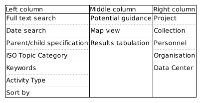
Outline of the data portal search interface. The Data Access Portal has information in 3 columns. An outline of the content in these columns is provided above. When first entering the search interface, all potential datasets are listed. Datasets are indicated in the map and results tabulation elements which are located in the middle column. The order of results can be modified using the "Sort by" option in the left column. On top of this column is normally relevant guidance information to user presented as collapsible elements.
If the user want to refine the search, this can be done by constraining the bounding box search. This is done in the map - the listing of datasets is automatically updated. Date constraints can be added in the left column. For these to take effect, the user has to push the button marked search. In the left column it is also possible to specific text elements to search for in the datasets. Again pushing the button marked "Search" is necessary for these to take action. Complex search patterns can be constructed using logical operators through the drop down menu above the text field. Text strings that are not quoted are treated as separate words and will match any of the words (i.e. assuming the OR operator). Phrases may be prefixed with '-' to indicate no occurence of the phrase in the results.
Other elements indicated in the left and right columns are facet searches, i.e. these are keywords that are found in the datasets and all datasets that contain these specific keywords in the appropriate metadata elements are listed together. Further refinement can be done using full text, date or bounding box constraints. Individuals, organisations and data centres involved in generating or curating the datasets are listed in the facets in the right column.
Visualize timeseries
 Institutions: The University Centre in Svalbard
Show more...
Abstract:
The dataset are the raw data files from the Svalbard SuperDARN radar (data from other SuperDARN radars are also stored at this repository but this collection refers specifically to the Svalbard SuperDARN radar only). The data freely available and are archived in two open-access repositories (a username and password are required to access the system). The data repository at the British Antarctic Survey is used here. The SuperDARN community maintains two software packages to process and analyse the raw data : i) Radar Software Toolkit (RST), the primary SuperDARN data analysis software, ii) pyDARN, a python library for SuperDARN data visualisation
These open source packages are maintained and distributed by an international team of scientists, engineers and software developers.
The final (post processed) datafiles will contain line-of-sight doppler velocity, backscattered power and spectral width along the 16 pointing directions of the Svalbard SuperDARN radar at an altitude of 250km. The data coverage is of an area to the North East of Svalbard, across the polar cap, extending towards Alaska.Access: Registered users only (manual approval required)