- Citation of data and service
-
Always remember to cite data when used!
Citation information for individual datasets is often provided in the metadata. However, not all datasets have this information embedded in the discovery metadata. On a general basis a citation of a dataset include the same components as any other citation:
- author,
- title,
- year of publication,
- publisher (for data this is often the archive where it is housed),
- edition or version,
- access information (a URL or persistent identifier, e.g. DOI if provided)
The information required to properly cite a dataset is normally provided in the discovery metadata the datasets.
If you use data retrieved through this portal, please acknowledge the SAON Data Portal.
- Brief user guide
-
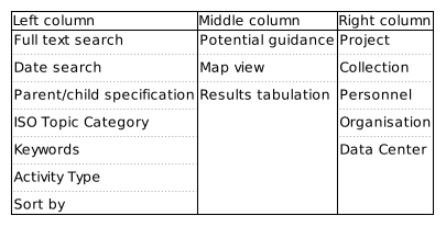
Outline of the data portal search interface. The Data Access Portal has information in 3 columns. An outline of the content in these columns is provided above. When first entering the search interface, all potential datasets are listed. Datasets are indicated in the map and results tabulation elements which are located in the middle column. The order of results can be modified using the "Sort by" option in the left column. On top of this column is normally relevant guidance information to user presented as collapsible elements.
If the user want to refine the search, this can be done by constraining the bounding box search. This is done in the map - the listing of datasets is automatically updated. Date constraints can be added in the left column. For these to take effect, the user has to push the button marked search. In the left column it is also possible to specific text elements to search for in the datasets. Again pushing the button marked "Search" is necessary for these to take action. Complex search patterns can be constructed using logical operators through the drop down menu above the text field. Text strings that are not quoted are treated as separate words and will match any of the words (i.e. assuming the OR operator). Phrases may be prefixed with '-' to indicate no occurence of the phrase in the results.
Other elements indicated in the left and right columns are facet searches, i.e. these are keywords that are found in the datasets and all datasets that contain these specific keywords in the appropriate metadata elements are listed together. Further refinement can be done using full text, date or bounding box constraints. Individuals, organisations and data centres involved in generating or curating the datasets are listed in the facets in the right column.
Visualize timeseries
 Institutions: CH01L, Swiss Federal Laboratories for Materials Science and Technology, EMPA, Section Air Pollution, Überlandstrasse 133, 8600, Dübendorf, Switzerland
Show more...
Abstract:
Ground based in situ observations of bulk_sampler at Einsiedeln (CH0015R). These measurements are gathered as a part of the following projects OECD and they are stored in the EBAS database (http://ebas.nilu.no/). Parameters measured are: precipitation_amount in precip (lwe_thickness_of_precipitation_amount), nitrate in precip (mass_concentration_of_nitrate_in_precipitation), pH in precip (mass_concentration_of_pH_in_precipitation), sulphate_total in precip (mass_concentration_of_sulphate_total_in_precipitation)License : OECD: Public open access. We encourage contacting data originators if substatial use of individual time series is planned (fair use data policy).-
Earth Science Information Partners Program, Earth Observing System Data Information System (ESIP, EOSDIS)
Show more...
Abstract:
This compilation of recent ice velocity data of the Antarctic ice sheet is intended for use by the polar scientific community. The data are presented in tabular form (ASCII), containing latitude, longitude, speed, bearing, and error ranges. A metadata header describes the source of the data, the time of measurement, and gives details on measurement accuracy and precision. The tables are available for ftp transfer.
Web pages developed specifically for this data set provide detailed information for viewing and selecting the velocity data. These pages contain large satellite image maps (available as jpeg files). The data sets used to create these images were contributed by several investigators, generally from already published work. Both in situ and image-based methods are used.
References for the data sets are included with the data tables. If you have well-characterized Antarctic ice velocity data you would like to contribute to this site, please contact teds@icehouse.colorado.edu. If you have any questions concerning the relevance of these data to your work please contact NSIDC User Services. -
Show more...
Abstract:
The University of Wisconsin Antarctic Soils Database contains data collected by Dr. James G. Bockheim and his colleagues from 1975 through 1987. Data include site information, air and soil temperature measurements, soil profile features, and surface boulder weathering features for 482 sites in the McMurdo Sound area of Antarctica. Soil profile descriptions are provided for soils inside the McMurdo Dry Valleys from 23 December 1975 to 22 December 1987, and outside the Dry Valleys from 13 November 1978 to 04 January 1986. Chemical and physical properties of soils at 214 sites are also provided. The study area is confined to 77 deg 7.5 min S to 78 deg S, 160 deg E to 164 deg E. Data are in tab-delimited ASCII text format, and are available via ftp. -
Show more...
Abstract:
Pedons included here represent Cryosolic (permafrost-affected) soils from across the Canadian North from Baffin Island in the east, to the lower Mackenzie Valley and northern Yukon in the west, and to Ellesmere Island in the High Arctic. Pedon locations are Pangnirtung Pass, Baffin Island, N.W.T. (8 pedons); Inuvik area, N.W.T. (2 pedons); Mackenzie Delta, N.W.T. (2 pedons); Tanquary Fiord, Ellesmere Island, N.W.T. (4 pedons); Lake Hazen, Ellesmere Island, N.W.T. (4 pedons); Eagle Plains, northern Yukon (3 pedons); Dawson City area, central Yukon (2 pedons).
Cryosolic soils, according to the Canadian soil classification, are either mineral or organic materials that have permafrost either within 1 m of the surface (Static and Organic Cryosols) or within 2 m (Turbic Cryosols) if more than one-third of the pedon has been strongly cryoturbated, as indicated by disrupted, mixed, or broken horizons. They have a mean annual temperature below 0 degree C. In the soil profile descriptions, the perennially frozen (permafrost) soil horizons are identified by the letter 'z'. The descriptions and nomenclature used to describe these pedons are according to - Expert Committee on Soil Survey. 1983. The Canada Soil Information System, Manual for describing soil in the field. Agriculture Canada, Ottawa, Canada. Agriculture Canada Expert Committee on Soil Survey. 1987. The Canadian System of Soil Classification. (2nd ed.) Research Branch, Agriculture Canada, Ottawa, Canada. The methods for laboratory analysis are according to - Sheldrick, B.H. (editor). 1984. Analytical Methods Manual. 1984. Land Resource Research Institute, Agriculture Canada,
Ottawa, Canada.
Additional information relating to these pedons can be obtain by contacting Charles Tarnocai, Agriculture and Agri-Food Canada, Research Branch (ECORC), K.W. Neatby Building, Rm. 1135, 960 Carling Avenue, OTTAWA, Canada, K1A 0C6; Tel.- (613) 759-1857; Fax- (613) 759-1937; E-mail- tarnocaict@em.agr.ca. The data file on the CAPS Version 1.0 CD-ROM contains laboratory analyses of the soil samples, including chemical, physical, mineralogical (clay mineralogy when applicable), and particle size distribution analyses. -
Institutions: US06L, National Oceanic and Atmospheric Administration, NOAA/ESRL/GMD, Earth System Research Laboratory, Global Monitoring Division, 325 Broadway, CO 80305-3, Boulder, U.S.A.
Show more...
Abstract:
Ground based in situ observations of ozone at South Pole (US6004G) using uv_abs. These measurements are gathered as a part of the following projects NOAA-ESRL, GAW-WDCRG and they are stored in the EBAS database (http://ebas.nilu.no/). Parameters measured are: ozone in air (mass_concentration_of_ozone_in_air)License : NOAA-ESRL: , GAW-WDCRG: -
Institutions: US06L, National Oceanic and Atmospheric Administration, NOAA/ESRL/GMD, Earth System Research Laboratory, Global Monitoring Division, 325 Broadway, CO 80305-3, Boulder, U.S.A.
Show more...
Abstract:
Ground based in situ observations of particle_number_concentration at Mauna Loa (US1200R) using cpc. These measurements are gathered as a part of the following projects GAW-WDCA, NOAA-ESRL and they are stored in the EBAS database (http://ebas.nilu.no/). Parameters measured are: particle_number_concentration in aerosol (number_concentration_of_particles_in_dry_aerosol_particles_in_air)License : GAW-WDCA: , NOAA-ESRL: -
Kyststrommen (Kyststrommen)
Show more...
Abstract:
This dataset includes Geophysical Institute (GFI), University of Bergen mooring NTS197409_B data. The mooring consists of 2 inst. (instrument type:instrument number(instrument depth)):RCM4:53(50m) RCM4:758(200m) . Metadata and raw/processed time series are presented as NetCDF, text and pdf(plots with statistics, calibration sheets, mooring drawing) files.Access: unrestricted -
Kyststrommen (Kyststrommen)
Show more...
Abstract:
This dataset includes Geophysical Institute (GFI), University of Bergen mooring NTS197409_A data. The mooring consists of 2 inst. (instrument type:instrument number(instrument depth)):RCM4:759(50m) RCM4:70(200m) . Metadata and raw/processed time series are presented as NetCDF, text and pdf(plots with statistics, calibration sheets, mooring drawing) files.Access: Open -
Not provided
Show more...
Abstract:
The dataset contains high resolution seismic reflection profiles from the inner part of Kongsfjorden, printed on paper, with selected profiles photocopied. The profiles were taken in summer 1974 during an investigation into glacial processes and the glacial history of Svalbard by G.S.Boulton. There was no attempt to systematically cover the whole of Kongsfjorden but to establish some profiles in what were judged to be critical or representative locations. It was hoped that the profiling would provide a seismic stratigraphy.
The dataset and data collection methods are described in the attached data report. The printed profiles are in storage at the Norwegian Polar Institute (geology archive).
Quality
The profiling system was based on a multi-electrode sparker. It was an analogue system with real time display of the profiling results, and no recording of the data to enable post acquisition processing. Adjustments to get optimum quality had to be done whist operating in the field situation, sometimes a quite difficult - and frustrating - task. Recording parameters could be quite sensitive. -
Kyststrommen (Kyststrommen)
Show more...
Abstract:
This dataset includes Geophysical Institute (GFI), University of Bergen mooring NTS197403_C1 data. The mooring consists of 2 inst. (instrument type:instrument number(instrument depth)):RCM4:670(140m) RCM4:672(160m) . Metadata and raw/processed time series are presented as NetCDF, text and pdf(plots with statistics, calibration sheets, mooring drawing) files.Access: unrestricted -
Kyststrommen (Kyststrommen)
Show more...
Abstract:
This dataset includes Geophysical Institute (GFI), University of Bergen mooring NTS197403_C data. The mooring consists of 2 inst. (instrument type:instrument number(instrument depth)):RCM4:670(60m) RCM4:672(160m) . Metadata and raw/processed time series are presented as NetCDF, text and pdf(plots with statistics, calibration sheets, mooring drawing) files.Access: Open -
Kyststrommen (Kyststrommen)
Show more...
Abstract:
This dataset includes Geophysical Institute (GFI), University of Bergen mooring NTS197403_A data. The mooring consists of 3 inst. (instrument type:instrument number(instrument depth)):RCM4:39(59m) RCM4:52(110m) RCM4:65(211m) . Metadata and raw/processed time series are presented as NetCDF, text and pdf(plots with statistics, calibration sheets, mooring drawing) files.Access: unrestricted -
Kyststrommen (Kyststrommen)
Show more...
Abstract:
This dataset includes Geophysical Institute (GFI), University of Bergen mooring NTS197403_B data. The mooring consists of 3 inst. (instrument type:instrument number(instrument depth)):RCM4:36(57m) RCM4:671(108m) RCM4:70(209m) . Metadata and raw/processed time series are presented as NetCDF, text and pdf(plots with statistics, calibration sheets, mooring drawing) files.Access: Open -
Institutions: CH01L, Swiss Federal Laboratories for Materials Science and Technology, EMPA, Section Air Pollution, Überlandstrasse 133, 8600, Dübendorf, Switzerland
Show more...
Abstract:
Ground based in situ observations of bulk_sampler at Oeschberg (CH0014R). These measurements are gathered as a part of the following projects OECD and they are stored in the EBAS database (http://ebas.nilu.no/). Parameters measured are: precipitation_amount in precip (lwe_thickness_of_precipitation_amount), ammonium in precip (mass_concentration_of_ammonium_in_precipitation), nitrate in precip (mass_concentration_of_nitrate_in_precipitation), pH in precip (mass_concentration_of_pH_in_precipitation), sulphate_total in precip (mass_concentration_of_sulphate_total_in_precipitation)License : OECD: Public open access. We encourage contacting data originators if substatial use of individual time series is planned (fair use data policy). -
Institutions: CH01L, Swiss Federal Laboratories for Materials Science and Technology, EMPA, Section Air Pollution, Überlandstrasse 133, 8600, Dübendorf, Switzerland
Show more...
Abstract:
Ground based in situ observations of bulk_sampler at Delemont (CH0013R). These measurements are gathered as a part of the following projects OECD and they are stored in the EBAS database (http://ebas.nilu.no/). Parameters measured are: precipitation_amount in precip (lwe_thickness_of_precipitation_amount), ammonium in precip (mass_concentration_of_ammonium_in_precipitation), nitrate in precip (mass_concentration_of_nitrate_in_precipitation), pH in precip (mass_concentration_of_pH_in_precipitation), sulphate_total in precip (mass_concentration_of_sulphate_total_in_precipitation)License : OECD: Public open access. We encourage contacting data originators if substatial use of individual time series is planned (fair use data policy).